DroneCamp 2023
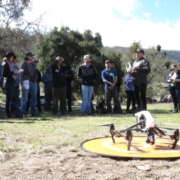
The 7th annual DroneCamp 2023 open for Registrations! We are excited to be offering this year’s program in a hybrid format where an in-person audience will be simultaneously viewing the presentations and workshops with a virtual live broadcast via Zoom for those who can’t attend in-person
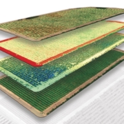
DroneCamp is a collaborative five-day training program that covers everything you need to know to use drones for mapping and field data collection. Now in its seventh year, Drone Camp 2023 will once again provide a unique drone training opportunity designed for a wide range of skill levels and interests, from complete beginners with little to no experience in drone technology, to intermediate users who want to learn more advanced data processing and analysis. Instructors from the University of California and California State University systems will provide workshops and hands-on training. No experience is necessary! To Register NOW and learn more: https://dronecampca.org/
Be sure to sign up for our email list to be notified with updates by clicking here. If you have any questions please contact info@dronecampca.org. We hope to see you there!