IGIS is pleased to host the third offering of DroneCamp! This intensive workshop covers everything you need to know to use drones for mapping, research, and land management, including:
- Technology – the different types of drone and sensor hardware, costs and applications
- Drone science – principles of photogrammetry and remote sensing
- Safety and regulations – learn to fly safely and legally, including tips on getting your FAA Part 107 Remote Pilot Certificate
- Mission planning – flight planning tools and principles for specific mission objectives
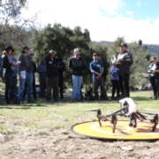
- Flight operations – hands-on practice with both manual and programmed flights
- Data processing – processing drone data into orthomosaics and 3D digital surface models; assessing quality control
- Data analysis – techniques for analyzing drone data in GIS and remote sensing software
- Visualization – create 3D models of your data
- Latest trends – hear about new and upcoming developments in drone technology, data processing, and regulations
Who Should Attend?
DroneCamp is designed for participants with little to no experience in drone technology, and who are interested in using drones for a variety of real world mapping applications. This training has an emphasis on agriculture and natural resources, but the methods for flight operations, data processing, and analysis are applicable to a broad range of disciplines, including archeology, surveying, and facilities management.
Note the focus of DroneCamp is using drones for mapping, research and data collection. We do not cover building drones, robotics, or videography. Regulations will be discussed but this is not a Part 107 prep class.
Experience with drones or GIS is not required. You do not need to bring a drone. See also the DroneCamp FAQs.
Stay tuned for registration details!